
Reports from 2021
January 2021
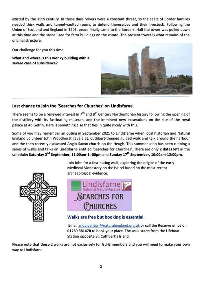
Wooler in World War II
Wooler in World War II
GLHS Report January 2021: ‘Wooler in World War II – a Defended Village’
Glendale Local History Society is grateful to Alan Sture for kick-starting the second half of the Society’s ‘lockdown’ season with its first webinar presentation via Zoom: ‘Wooler in World War II – a Defended Village’.
Few would believe that Wooler had held such a significantly important, defensive position during World War II ─ all was revealed with Alan’s well-researched and illustrated analysis and explanation. He started by posing three thought-provoking questions: (a) “Was Wooler a rural backwater or a key defence point for the entire region? (b) If it was key, then why was it so important? (c) Would the Germans really have invaded this part of the country?”, and continued by explaining why Wooler was a noteworthy place requiring substantial defences. Alan also explained that, contrary to popular belief, there was considerable anti-invasion planning before Dunkirk, and that the threat of invasion continued after the Nazi attack on Soviet Russia.
The inter-war years created the conditions for the preparations that took place. The armed forces had been considerably reduced to be virtually ineffective. From the time of the German withdrawal from the League of Nations in 1933 to the outbreak of war in 1939, plans were formulated, argued over and re-formulated. From 1938 onwards, the general public became involved, with the distribution of gas masks, digging of shelters and air raid precaution practice. Not until 1940 was the necessity and availability of manpower for home defence considered critical - most of British military manpower having been focussed on supporting the BEF in Norway, Belgium and France, with home defence reliant on British air and naval forces. In late 1939, thought was given to a possible invasion from North German ports to strategic areas, including the Tyne-Tees region. Military planners also considered a potential enemy assault, via ports or beaches, from the far north, aiming south to strategic targets of the North East, Midlands and London. “GHQ Lines” and “Stop Lines” were developed in 1940 when measures were taken to prevent enemy movement in priority inland areas. Alan also explained that the rapidly changing circumstances, along with three changes of Commander-in-Chief, Home Forces within a short time span, each with a different approach to the threat of invasion, led to the frenetic activity of the spring and summer of 1940.
Clear potential route-lines were illustrated on Alan’s maps with the diagrammatic anti-tank ‘Stop-lines’ ─ Wooler was at an intersection of two of these in this area. As a result of a mammoth effort from 1940 onwards,manufacturing over 18,000 pill boxes nationally, Wooler eventually boasted no fewer than 13 plus pill boxes which encircled the village, many of which still stand today, along with a variety of strategically-placed road-blocks ─ varying designs were described and superbly well illustrated. Pill boxes were initially manned by thinly spread Home Defence Forces but later by the Home Guard until this form of protection was abandoned.
Alan then detailed information concerning some of the people involved, from the regular military units to the volunteers of the Home Guard, Auxiliary Units, Women’s Land Army and other support services. This was followed by a slight digression to talk about RAF Milfield, a substantial self-contained base but whose personnel interacted with Wooler in many ways.
This gives only a flavour of his clear informative presentation. For the illustrated talk presentation and his conclusions please visit: www.glendalelocalhistory.org link: ‘Talk Reports - January 2021’.
February 2021:
Geology and Industrial Archaeology of the coast of North Northumberland from Berwick to Holy Island
For those uninitiated in the field of geology, Elizabeth Devon gave a clear explanation, illuminating its links with landscape, soils, vegetation, land use, settlements, industry and climate, to a virtual audience of members and guests of the Glendale Local History Society.
Elizabeth challenged her audience to look around their home and identify anything that did not come from the soil – everything does - e.g. wood from trees with their roots in the soil, wool from sheep which eat grass with roots in the soil, china, pottery and plastics from minerals and petro-chemicals from the earth, mined ore for metal, etc.
Our industrial heritage developed from geological resources exploited by humans for millennia. During the Bronze Age, copper & iron were mined; the Iron Age and Roman periods saw further use of minerals, and our more recent Industrial Revolution made use of coal, lime, iron ore and much more.
How many of us knew that 500 million years ago parts of what now comprises the British Isles once lay south of the Equator only to drift north-east? Indeed it is still doing so! Since then this landscape has been periodically frozen under thick glacial ice – alternating with warmer epochs. Over time, shifting plate tectonics and huge earth movements have caused collision of rocks which became ‘folded’, and ‘faulted’, generally dipping to the south-east in this north-eastern coastal area.
Ice Ages are cyclical, with four having been recorded, the last one being some 12,000 years ago. During these periods of climatic change, sea levels rose and fell. When they fell, resulting deposits of sand and silt were carried by rivers, via deltas, to coastal areas, becoming compressed into sandstone and mudstone. High sea levels caused forests and swamps to become drowned, later compressed to form peat and eventually coal. Evidence of fossilised trees and tree roots systems can be found in local rocks (for example at the southern end of Spital beach), whilst ancient corals, sea-animals and shells, having fallen to the sea floor, became compressed, creating limestone exposed during times of low sea levels. This historical building of layers of geological matter - predominately limestone, sandstone and mudstone, together with some coal - was all deposited horizontally and compressed into sedimentary rock - as a direct result of cyclical sea-level changes associated with climatic cycles of Glacial and Interglacial periods (ice-age to green-house!). A graphic timeline conveyed the context in terms of mankind’s relatively short existence , with the following discussion focussing on the Carboniferous era, about 320 million years ago, to which the rocks in this area can be dated.
Early examples of local geological influence include building historic Berwick Castle of limestone, and the Berwick Fortification Ramparts made from limestone and sandstone. C19th coastal industry, south from Berwick’s Cocklawburn, reveals evidence of extensive quarrying all the way down the coast. Limestone was not only quarried for building stone but also for making quick-lime, by fuelling lime kilns with layers of coal and limestone. Quarrying sandstone, limestone, aggregates together with coal-mining, extraction of clay and salt-panning, created thousands of jobs for men from a wide area, including from Ireland as a result of the potato famine. The work was hard and dangerous, using sledge-hammers and picks to hack out large pieces of rock by brute force, together with the exposure hazards involved with quick-lime. After centuries of use, these industries declined but remains can be observed as spoil heaps, scars, current settlements, place names, old lime kilns, and pits now made into nature reserves ponds.
Local industrial activities were totally influenced by the local geology, and our speaker gave a well-illustrated, enthusiastic, informative interpretation of this all-encompassing subject which, far from being static, evolves and gives life to all over the millennia.
March 2021: (GLHS Talk via Zoom)
Royal Mail Coach Routes through Northumberland and the Borders 1790-1840
Speaker: Ian Rawles
The Society was treated to a fine, well-illustrated talk, which generated a long discussion among members. The focus of the talk was on arguments about changing the Royal Mail coach route between Newcastle and Edinburgh, but through this lens, our speaker, Ian Rawles opened out many other issues about the society and politics of the time. The established route, from London to Edinburgh, through Newcastle, followed the old A1, but the stretch from Morpeth onwards was longer than other possible routes and landowners and businesses interests lobbied vigorously for change to shorter routes. As background to the arguments, Ian Rawles introduced us to the mail coaches, of a standardised design, pulled by four horses. The coaches changed horses every ten to fifteen miles to maintain speed with fresh horses, with changeovers taken just a minute or so. Each coach had a uniformed guard who sat at the back, equipped with pistols and a horn. The drivers were skilled horsemen and there was space for three passengers. The routes fanned out from London to the rest of the country and were an important way to draw the whole of the United Kingdom together. Our speaker said it was a great sight at the time to see the coaches ready to depart from central London, and must have impressed people with power of the State as the coaches flew by at ten to fifteen miles an hour through rural Northumberland.
Sir Francis Freeling was in charge of the Royal Mail service from 1790 to 1836, and was keen to reform the service, and especially to speed it up. There were many interests lobbying for improvements, including government needing better communication, lawyers who needed a secure way to deliver papers and businesses who needed quick answers to queries. People in Scotland lobbied hard for better communication north of Edinburgh, while many people thought a royal mail route would lead to road improvements. Engineers, such as the great Thomas Telford, were also pushing for major highway schemes using new engineering innovations. Finally, many landowners could see the benefits of a Royal Mail route through their land.
The four routes in discussion were: The existing A1 route; the Wooler line, more or less along the modern A697; the Carter line, more or less along the A696 and the Jedburgh line, via Hexham. The discussion about each route went on from the late 1780s until a final decision was made in 1830. Ian Rawles explored how the decision was made, and the relative influence of scientific and engineering analyses versus political influence. The Royal Mail had their own surveyors and assessed the alternative routes in terms of distance, topography, weather and financial return. The Jedburgh route was quickly dismissed because of topography and weather. In good weather, the Wooler and Carter lines won out when carefully assessed against the A1 route. On the Wooler route, there were some problems of topography. Passengers sometimes had to get out of coaches on steep parts of the route to lighten the load the horses had to pull. Thomas Telford advised about changing the route across Rimside Moor north of Long Framlington to avoid a particularly steep slope. As regards finance, the postal service needed to make money from people who paid to deliver packets and letters, perhaps another reason why the Jedburgh line dropped out of consideration.
But these technical arguments were only one side of the story. At that time, landowners wielded considerable power at all levels of government. During the course of his research, Ian Rawles found petitions and letters from landowners and others influential people strongly advocating the Wooler line, including one from Ann Roddam of Roddam Hall. The Blacketts of Wallington Hall advocated the Carter line, while Viscount Morpeth, later Earl of Carlisle, a significant Whig politician, promoted the Wooler line. However, the Duke of Northumberland argued to maintain the Berwick line, which of course ran through his seat at Alnwick. So ‘old money’ linked to the Duke confronted the modernisers associated with the Whig party. In the end, a clever behind-the-scenes compromise allowed both routes to proceed. The Royal Mail Coach continued to follow the A1. A new additional service was introduced for the Wooler line using a light curricle pulled by two horses. This was both faster and cheaper to run than the Royal Mail Service. This service was a great success until 1837, when a quite different technology – the railway – overtook it. The last Royal Mail coach left Newcastle for Edinburgh in 1847.
We all found Ian’s talk a fascinating insight into our area at an important moment in its history, with the industrial and agricultural revolutions getting underway.
April 2021: (GLHS Talk via Zoom)
‘Holidays in the Cheviots: 1910-1915’ - the story behind the story
Speaker: Pam Ratcliffe
Petersfield, just above Wooler Common car park, is a familiar land mark to most of us today, but at the beginning of the last century, it was the holiday home of a Scottish doctor and his family, who recorded their visits there between 1910 and 1915 in a journal.
Pam gave a tantalising glimpse of the day-to-day events and the people involved in this remarkable snapshot in time, which has now been transcribed and published in a book, a review of which appears below.
Sometime in the early 1900s, the Ford Robertsons from Edinburgh bought a house called Petersfield, up in the hills beyond Wooler. From 1910 to 1915, on regular visits throughout the year, they turned it into multi-faceted holiday home. During the term-time months, they sometimes popped down for the weekend, but over Easter and the summer, the whole household – Dr and Mrs Ford Robertson, their three sons, twins of 11 in 1910 and a younger brother, spent several weeks enjoying Wooler and the Cheviot Hills. For longer holidays, they would arrive by train at Wooler station, to be met initially by the Black Bull’s horse-drawn ‘wagonette’, later replaced by a motor vehicle. With one or two servants, a good deal of baggage, and even a piano, they were already quite a large group. Over the years, they were joined by many other visitors. Relatives and friends came to stay and there was always a flow of day visitors – some of them other families holidaying in the area, and local friends. These included the Archbold sisters, who then lived in a pair of houses, Craigrossie, in Ryecroft Way in Wooler.
We know all this, and much more, because of the daily log they kept of their activities. Dr Ford Robertson, sometimes referred to as ‘the patriarch’, must have created this log-keeping practice, meticulously maintained during his absence by one of the boys, an uncle or a visitor. These absences were quite frequent as Dr Ford Robertson was the Pathologist to the Scottish Asylums, and was becoming a distinguished expert in the mental health field. Several of the family’s visitors were also fellow medics. He commuted back to Edinburgh weekly in extended holiday periods, catching the 9.33am train from Wooler. Dr Ford Robertson is also known to those interested in the history of walking in the Wooler area as the author of a very detailed book of Walks from Wooler, published in 1926. The log book shows just how well he knew the routes described in this book. Hardly a day went by without a long walk over the hills, although the family allowed themselves more rest on a Sunday. They clearly enjoyed ranging over the hills in all weathers, while occasionally organising a more social event, such as a picnic, or going on fishing expeditions to favourite spots. There is a wonderful account in the log book of the experience of using a ‘motor vehicle’ to reach the Langlee Valley. This early car struggled with steep slopes and eventually drifted into a stream. The family had a few car trips after this, but when ranging further afield they mostly went by train.
They did much more than walking, however. There was a daily schedule of work to be done, fixing the house and creating a garden. The boys mucked in and their contributions were recorded in the daily log (and occasionally expanded on when one of the boys wrote an entry). Each summer the house seems to have got bigger, with more rooms added and facilities improved. The garden was large – sloping down from the house to a marshy area and stream. They created a vegetable garden, planted soft fruit bushes, laid out rockeries and flower gardens, and levelled the ground to make a tennis court. After much effort, the boys managed to dam the stream to create a place where they could swim. In addition to all this, the house party played sports – tennis when the court was finally ready, but also cricket. The boys used bows and arrows and took lessons in the use of rifles. To begin with their biggest success was in shooting rabbits, but by 2014, with the twins coming up to 15 and the First World War breaking out, shooting practice must have felt more serious.
We know about this log book because it was found by chance a few years ago, and has been meticulously transcribed and turned into book form. Holidays in the Cheviots 1910–15 is the result. Curated by Pam Ratcliffe, who also provides a very informative introduction, and produced by Glendale Local History Society, it is an enjoyable read in itself, as you follow family life on a day-to-day basis. It is also full of other insights into the life and times of a middle-class professional Edwardian family. It provides a window into Wooler life at the start of the 20th century, and some Wooler families of today may find mention of their ancestors – Shorts, Redpaths, Richardsons and Murrays, for example. The book is also a useful resource for those interested in the transport. Motor vehicles were just beginning to challenge the horse and train. From 2014, WW1 events are recorded from time to time, as the family regularly went into Wooler for a newspaper. And there is a snippet of history of the Scouting movement, as the boys were involved in a scout group in 2010, just two years after the movement was founded. But above all, the log book records the life of a busy and active family, who enjoyed being outdoors and filled their days with energetic activity and projects of many kinds. Perhaps Dr Ford Robertson wanted to show by example the mental health benefits of such a life.
Holidays in the Cheviots can be obtained from Glendale Local History Society, c/o Cheviot Centre, Padgepool Place, Wooler, NE71 671 6BL, or via email to: [email protected], or direct from the Cheviot Centre or Brands in Wooler. The book costs £7.50 (£2.50 postage in addition).
September 2021
Angels of the North
Speaker: Dr Moira Kilkenny
Finally, after 18 months of pandemic restrictions, GLHS was able to host a live talk. An audience of 40 listened to a fine presentation by Dr Moira Kilkenny on the work she and her colleague Joyce Quin have done celebrating women from the North East, whose significant contributions have been neglected in national biographies and collections of lives of the ‘great and good’. This neglect, she argued, is partly because, until recently, women have been neglected anyway in such accounts, but also because the North East tends to get overlooked. She reminded us of the dominance of a patriarchal society in our country, right up to the twentieth century, in which women were relegated to the domestic sphere and the role of education was merely to prepare them to be good mothers. Some men even argued that education was bad for women’s minds and bodies. Meanwhile, many women were expected to slave away as servants and factory workers with little appreciation. Yet some women challenged this identity and strove against it.
In their search for significant women, Moira and Joyce identified forty people, selected for their bravery, their heroic deeds and/or their innovative contribution. Short biographies of all these are provided in their book Angels of the North, published in 2018 (see details at the end). For our talk, Moira selected 10 women with Northumbrian connections. Some of these are already well known, such as Grace Darling, whose rescue of drowning sailors in 1838 got national attention at the time. The story of an ordinary young girl prepared to risk her life in heavy seas seemed so extraordinary, given the ideas of women’s capabilities at the time, that she attracted national attention for her heroism. Lady Waterford came from a much higher class. In addition to her philanthropic works, she was a fine artist. Many of us know of her work in the Waterford Hall at Ford, but her paintings found their way into national galleries. Then there was the social reformer, Josephine Butler. Our speaker thought she was the most distinguished social reformer of the nineteenth century. She was born a Grey, and her father was a cousin of the Earl Grey who introduced the social reform legislation of 1832 which began to open up the franchise to many more people (though not to women!). After being devastated by a family tragedy, Josephine turned to social reforming, especially focusing on the treatment of women prostitutes by authorities trying to reduce sexual diseases among men. She was a powerful speaker and a skilled campaigner despite the hostile reception she often got, and travelled to other countries to promote better treatment for many women thrust into prostitution because they lacked other alternatives. Emily Wilding Davison is also well-known these days in the North East as a leading suffragette campaigner who died trying to pin the suffragette colours onto the Kings Horse at the Epsom Derby in 1913. Our speaker’s view is that this was not an intended suicide.
Then we were introduced to several others who are less well known. We were told about Charlie (Charlotte) Marsh, another militant suffragette who went on hunger strike when imprisoned and was force fed. Lady Sybil Grey trained as a nurse in the first world war, converted Howick Hall into a convalescent home, and set up a hospital for wounded soldiers in Petrograd. She also organised the repatriation of nurses from field hospitals in war zones. Mabel Philipson was at one stage of her life a Gaity Girl, but later become the North East’s first woman MP. Dame Irene Ward, also in the twentieth century, became the ‘mother of the house’ as a longstanding MP. Moira’s talk ended with the example of Ida and Louise Cook, two sisters from Sunderland who went to school in Alnwick. They wrote stories for women’s magazines and got a contract with Mills and Boon. They made good money out of their writing, which enabled them to travel across Europe. In their travels, they became aware of the increasingly perilous position of Jewish people. They used their money to enable many Jewish families to move to the UK, often acting as intermediaries between people in need and people who could help. They also helped by carrying the possessions of some Jewish families through the various military check points. Just ‘ordinary girls’, as they saw themselves, their bravery and ingenuity were later honoured by Israel, and, eventually, the British government.
After inspiring us with her accounts of what these women achieved, despite male prejudice, our speaker concluded that Northern women were (and are) capable of great things. And we all agreed!
The book: Angels of the North: Notable Women of the North East, by Joyce Quin and Moira Kilkenny, 2018.
October 2021:
‘The Cult & Culture of Monasticism’
Speaker : Margaret Kirby.
Our speaker, Margaret Kirby, presented a very well-illustrated and knowledgeable account covering 1000 years of monastic culture, from an era when religious houses were an influential feature of everyday life in Britain. We heard that monastic life started in Egypt in C313 with the first ever recorded monastery, that of St Catherine, in the Egyptian Sinai desert. At that time Christian monks sought to emulate Christ by seeking solitude, austerity and prayer. Thence, monastic life spread throughout north-western Europe, particularly to France. Indeed St Patrick was schooled in monastic culture on the French Mediterranean island of Lerins before returning to concentrate on extending rural monastic life at home in Ireland. The Irish Church flourished owing to the island generally escaping much of the European warfare hence Ireland become a centre of Christian culture and education. Resident communities spread, the Irish Church became established overseas in France, Switzerland and Italy.
Initially, however, some Irish monks had followed a very austere, isolated, contemplative life-style of deprivation and solitude as hermits, with remote archaeological remains, from this period, being found on the remote rocky outcrop of Skellig Michael, off the south western coast of Ireland, an example. However, monasteries in a wider area evolved over time and the St Benedict Rule brought regulation to Benedictine monks’ living, but over centuries the rules became more relaxed with less physical labour allowing further development of the arts, plain song and the design of more elaborate churches. Fine artistic skills developed as monastic residents illuminated manuscripts (e.g. Lindisfarne Gospels & the later Book of Kells) influenced by Byzantine & Mediterranean and Irish artwork, sometimes with scribbles, reflections or poetry in the margins ─ we heard sample quotations. Fine examples of stone-carved crosses with varying ornamentation, again with Mediterranean influence, are to found throughout Ireland. Over time, craftsmanship extended to include metal work with decorative filigree on Chalices, coloured glass-work in windows and the use of Vellum.
A steady stream of travelling monks extended influence to Scotland and Northumbria with St Columba founding the great monastery on Iona. Further Irish influence is seen at religious sites at Lindisfarne, Jarrow, Wearmouth and Durham. We heard of miracles associated with the body of St Cuthbert having been found ‘incorrupt’─ totally preserved ─ within his coffin, and of consequent pilgrimages to Durham where the cathedral was founded in his honour. Vast income was made from the purchase of ‘relics’, (souvenirs in modern parlance): anything (including bones) associated with the contents of the coffin.
St Bathan’s name was given to the Borders abbey and settlement. Locally, Eccles also relates to an ecclesiastical site and there remains a church of Irish origin at Escomb. Leading women also featured as with St Hilde at Whitby Abbey. However, the Irish, or Celtic, church was challenged ─ owing to a debate over the timing of Easter ─ at the Synod of Whitby (664AD) when acceptance of the Pope as head of the Church established Roman ecclesiastical authority. Over centuries reforms brought new orders of monks. Abbeys in this wider area flourished, including those at Coldingham, Melrose and Jedburgh, with Kelso being the greatest and hosting the baptism and crowning of Kings of Scotland. Such establishments developed sheep farming selling wool, gaining further profits, and thus becoming enormously wealthy.
Towards the end of the first millennium, people thought the Day of Judgement was near; gifts of great wealth were bestowed upon monastic orders. Monks, being held in high regard, were paid to pray for people’s souls and forgiveness of sins (in chantries); they were employed to fast as a penance for others’ wrong-doing (as today an insurance is understood). Monastic buildings became decoratively richer and more elaborate. However, this was not to last ─ decline began with some monasteries meeting their demise even before Henry VIII’s Dissolution of the Monasteries.
This report is incapable of giving the detail presented to us, we should therefore appreciate what remains of these great establishments, especially in the Borders, from the previous millennium of Cult and Culture of Monasticism ably recounted by our speaker and her theatrical assistants (Jenny & Frank) who read quotations, testimonies and poems of the era.
October 2021
GLHS Walk to Kirknewton
Speaker : Sue Rogers
The purpose of this guided walk was to draw people’s attention to landscape features that indicate the ancient origin of a public right of way recorded on Northumberland’s definitive map, which as it is a legal document, protects the public rights illustrated for future generations.
Just how ancient the particular right of way is which links Wooler to Kirknewton, that we were investigating, can’t be told just by looking at it. Even with the help of nineteenth century maps and documents, we still can’t tell when people first used it to carry their goods in their carts between those two settlements. But we can say that it existed at least as early as 1828 as it is shown on Greenwood’s map of Northumberland. We can also say that it ceased to be ‘customary’ way and became a legally recorded route in 1867 as it was recorded as an awarded public highway in the local Inclosure Award of that date.
To get to a point where we could pick up this route, we needed first to walk up the track towards Torleehouse, currently recorded as public footpath 229/009. We battled against a cold wind up this modern track, dated by its first appearance on 20th century OS maps.
Eventually we reached the point where a ‘restricted byway’ crossed it, as indicated by the purple waymarks. Until only 3 years ago, they would have been yellow, indicating that Kirknewton parish council had recorded its status as public footpath in error in the 1950s parish survey.
At this point one could see a well defined grass track winding up hill through a gateway on its way to Wooler but we had come to look at the short section leading down to Kirknewton.
There was a wide lane about 25yds wide with a stout wall on one side and a deep ditch with the remains of wall footings on the other. Undoubtedly the ancient route will have passed down it and it probably would have provided shelter for drovers and their stock on the move through the area. Cattle from south west Scotland travelled this way to join the old turnpike, now the A697, which would have provided a route to the markets at Morpeth and Newcastle.
But to be part of the ancient route it would be necessary for there to be a gate at least 8 ft wide as required for Cartways by the 1835 Highways Act. These were found at either end, with fine stone gate posts still in place at the south end.
However that lovely lane is now blocked by gorse and fallen trees so we had to detour into an adjacent pasture. This is legal as the definitive route was blocked to even those on foot, let alone those on horseback or with a horse and cart (pony and trap). We guessed that this obstruction will have developed in the early 20th century as local transport became mechanised so the route of the current tarmac road to Kirknewton via Akeld provided a faster, if longer, route from Wooler. It is now up to the Northumberland National Park to clear it for use by all those who now have public rights, even if some of those rights have been in abeyance for many decades. Public rights do not disappear because the public are unable to exercise them. ‘Once a highway, always a highway’ is the legal maxim, which protects those rights from long ago.
When we emerged at the northern end we were faced by an impassable gateway with a poorly drained surface which will be a challenge to restore. But in the meantime we were able to use stepping stones and a ladder stile to circumvent the obstacle. The final section took us across old pasture and along a well-defined hollow way which descended diagonally across the hillside to reach the lane to Kirknewton. This was not the direct route to the village but will have evolved to make it easier for those laden carts using this route in earlier centuries, whose weight will have worn away the ground to leave this distinctive feature.
We were not surprised to discover that a small building alongside this final lane is labelled ‘smithy’ on old OS maps. They provided an essential service and every small village and hamlet had one close to a busy route, as this one would have been. Inside one could see the old chimney and the surface across which the iron being used to make the horseshoes was placed, with room for the fire underneath. There was even an iron ring still on the wall to which the horse would have been tied.
There are a large number of these old features to be seen in the countryside which help one to understand the evolution of the rights of way and rural road network. It is worth opening one’s eyes and becoming a ‘landscape detective’ as you enjoy your walk in the hills. You may even be able to help save an ancient route or forgotten rights from extinction in 2026, as is going to happen as the result of the Countryside & Rights of Way Act 2000.
November 2021
Mediaeval Monasteries, Medicine and Care
Speaker: Sandra Gann
Our speaker, Sandra Gann, had worked as a Lady Almoner, known now as a medical social worker, at St Bartholomew’s Hospital. Her role was to relieve the social, emotional, practical or financial stress of patients and their families in the belief that stress impedes recovery. Since retirement she has studied ancient medicine and mediaeval cookery so was well versed to portray the mediaeval systems of health care.
Sandra described the spread of mediaeval hospitals following the Norman Conquest, saying that most care took place in monastic hospitals, such as St Bartholomew's Hospital in the City of London ─ the oldest hospital from 1123 and the only one still offering health care on its foundation site. St Thomas' Hospital was founded 4 years before but has moved site. The smaller ‘Maison Dieu’ (House of God) group, set up by local dignitaries or institutions, was the forerunner of the alms house. A sign depicting such a site can be found on Berwick’s old stone bridge; it was founded by Philip de Rydal c1250 for travellers, pilgrims and seafarers. A sign along the Kelso to Coldstream road indicates a farm, so named, where an old stone wall exists indicative of an ancient ruin of such a place. Leprosaria were common, where those suffering from leprosy and other skin conditions sought haven.
In Berwick, maps show evidence of many historical sites through names such as Spittal (giving rise to ‘hospital’). Examples include a Lazar house of St Bartholomew's at Tweedmouth, St Edward’s along the south side of Love Lane by the River Tweed, founded by The Trinitarians (Red Friars), for the sick and poor. St Mary Magdalene, by Berwick golf course, was first recorded in 1296, but founded before then; there are no visible remains, but in 1910 a sandstone sarcophagus and other ecclesiastical architectural fragments found there date from the 12th century. There is a Spittal house in Paxton which is thought to be linked to the Coldingham Abbey.
Another such establishment is recorded to have existed in Wooler: St Mary Magdalene Hospital on the corner of Ramsey’s Lane and Oliver Road recorded last in 1480 but thought to date from 1288.
At Soutra Isle in the Borders, en route to Edinburgh, one passes a sign to the remaining Church of the Holy Trinity, a memorial to an Augustinian monastery of 1164 where a hospital 700 sq m. with brewery, gardens and laundry once existed. A scandal occurred in the 1460s, when the Master, Stephen Fleming, was accused of misconduct and the monastery closed down with assets transferred to the New Trinity Hospital on the site of Waverley Station, Edinburgh – look for the sign near platform 11 (under the stairs). Dr Brian Moffat, an archaeologist and botanist, has excavated the site and found evidence of plants and medicinal products, establishing evidence for both the illnesses and treatments from the Middle Age era.
The practice of mediaeval medicine at this time was rooted in the Greek tradition based on the four humours introduced by Hippocrates, developed by Galen and linked to the four elements: blood, phlegm, black bile, yellow bile. These 4 substances were organised around the 4 elements, the four qualities of cold, hot, moist and dry, and around the 4 seasons. When they were in harmony, the person was healthy – an imbalance leads to pain and disease. Thus the aim of the healer would be to rebalance the humours. This could be the environment, as well as remedies noted for their heat or coolness, needed to maintain balance for good health. Care varied from blood-letting (releasing ‘bad blood’) to the all-important use of plants – monasteries had Physick Gardens; herbs and plants were very important to mediaeval medicine. The monk-healers used herbs from their physic gardens and people would often come to them for ingredients for remedies. Most people could not afford the few doctors who were trained; at this time the more common practitioners were apothecaries, alchemists and the widely used 'cunning folk', usually women with an accrued knowledge of folk-lore using plants and superstitious rituals. All practitioners, whether professional or amateur, needed a good knowledge of astrology, as the position of the planets played an important part in both diagnosis and remedy. Belief that movements of the stars and planets influenced the inner workings of the human body was widely held.
In the 13th century people believed that the soul was more important than the body, but the care and attention given to patients of these hospitals would have been a welcome relief from the worries of fire, famine or fever in the community at that time.
Finally, it was suggested that the mediaeval monastery hospitals had similar aims to our own in the 21st century by helping patients find ways of managing disability and disadvantage to aid health.
Profound thanks were given to Sandra for her stimulating talk.
November 2021
GLHS guided walk: Wooler in World War II
Speaker : Alan Sture
On 24th November, Alan Sture led 15 members on a guided walk around central Wooler, bringing to life the talk he’d given to the Society entitled Wooler in WWII (available to view on the GLHS website).
Far from a quiet backwater, Wooler was a key defensive point in North Northumberland, and the administrative, supply & social centre for army personnel, Milfield RAF training camp, & a POW camp. During the war the town was ‘full’, the ‘resident’ population of just under 2,000 swollen by military personnel, evacuees, the Women’s Land Army, civil administration personnel & POWs.
Alan explained that, with the threat of war, training started for first aid and Air Raid precautions in 1938. In 1939/1940 frantic preparations began to repulse any invasion by sea or air. The east coast was considered particularly vulnerable so, as backup for the defences at the coast, inland ‘stop lines’ were planned to prevent the enemy reaching the industrial areas.
The Essex Regiment was based in Wooler for 6 months 1940–41, billeted in Loretto House (Fairfield Hall), the Temperance Hall (Hope House, Church Street), and private houses. Military vehicles were parked around Burnhouse Road and a fleet of buses was stationed in Ewart Park ready take the troops to the defensive positions at the coast.
Wooler was strategically important because of its position at the intersection of two stop lines: it became a ‘defended village’, ringed by 13 pillboxes. Ten roadblocks monitored traffic – fifth columnist Nazi sympathisers were feared even in Wooler (in spring 1939 Oswald Mosely held a rally in the Archbold Hall).
Nationally, approximately 18,000 pill boxes were built between 1940 and 1942 each according to one of eight basic designs but there were regional variations. Their construction was often sub-contracted to local building firms, one company in the South East completing 200 in three weeks! A local builder, George Elliot, built the form work for the Wooler pillboxes. Anti- invasion planning continued until the latter part of 1942, as the British Commando raid on the Bruneval radar site showed that medium to large-scale raids by special forces were still possible.
Our walk began near the Cheviot Centre, then the offices of Glendale Rural District Council & in 1939 the temporary HQ of 162nd Defence Brigade of the East Anglian regiment. GRDC was charged with coordinating the wartime agricultural committees.
At the bottom of Ryecroft Road, the newly-built Ryecroft Hotel (refurbished as flats in 2020) was requisitioned by the army as an Officers’ Mess before it had even opened as a hotel and, between February and December 1941, it also served as the HQ for the 225th brigade of the Northumberland (County) Division.
Alan led us through Fenton Grange to an easily accessible pill box overlooking the (now disused) railway line and the roads across the Millfield Plain. As a last line of defence, the
Home Guard would man the pillboxes, this one with a light machine gun, but as fear of invasion faded local children enjoyed playing in them.
Returning to the A697 and the Berwick Road junction, site of a wartime roadblock, Alan showed us photographs of different types of roadblocks: ‘hairpin’ and ‘hedgehog’ layouts, and obstructions including moveable concrete blocks and broken-down vehicles.
The railway line with its four sidings at Wooler was kept very busy: troop movements; tanks from the local munitions factory at Melrose; evacuees and later POWs. The station waiting rooms provided accommodation for the Women’s Land Army until their hostel was built in 1942. From 1942 Akeld station became the railhead for building & supply of RAF Milfield;
Walker’s Garage, the house immediately north of what is now Hope’s Garage, became the NAAFI’s supply depot for all North Northumberland.
We crossed Wooler Water on the Chatton Road bridge. Alan explained that here the roadblock consisted of gunners in a shoulder-height trench along the road and two upstairs in the first house in Weetwood Road. All the bridges were mined with explosives, as a last resort to hamper any invasion.
We continued through Scott’s Park, which had been an extensive, fortified railway loading dock. We looked across South Road to what was the Drill Hall Cinema where, throughout the war, there were four programmes a week, and two showings held daily Monday to Saturday, including Christmas Day.
Along Brewery Road, on the site of what is now the middle school, was Prisoner of War (POW) Camp 105. From 1942 it housed 600 Italians, who were moved out to Chatton, Hagerston & other satellite camps in 1944 so that ‘white’ German POWs (those considered to have little or no Nazi sympathies) could be held there, and then from 1945–8 it held displaced persons, mainly from Eastern Europe.
At Wooler Bridge, Alan described how it was made a single lane, controlled by three roadblocks on the access roads to the north, south and east, with firing points in what is now the Riverside Bar. Pillboxes were placed to prevent tanks using any alternative routes and so maintain control of the Milfield Plain.
In the Market Place, Alan explained that Wooler was the commercial & social hub for a wide area: the shops and the popular Saturday night dances at the Archbold Hall in Church Street served both the town’s resident population of just under 2,000 along with the 2000 servicemen and women at Milfield, and those staffing the POW Camp. (Servicemen based near Wooler included at one time Intelligence officers Dirk Bogarde and Anthony Quayle.)
Wooler was on the flight path to the vital munitions factories around Glasgow, so searchlights were positioned in Cheviot Street. Fortunately the town escaped bombing raids apart from on 7th April 1941, when 30 bombs & incendiary devices were dropped, damaging two properties.
Alan gave us a most informative and entertaining walk, enabling us to appreciate Wooler’s role in both in defence and in preparation for D-Day and victory.
December 2021
The History of Glanton Pyke and its Garden
Speaker : John Sawnson
Rescheduled from October, due to unforeseen circumstances, John Sawnson gave his talk on “The History of Glanton Pyke and its Gardens” on Wednesday 8th Dec.
He began by displaying a litho, 300 years old, of the original country house ay Glanton Pike. He went on to trace the origins of the families who had lived there, for over 200 years, before he and his wife bought it in 1987.
The Mills family had owned land in Glanton from 1699, and 4 years later the first Joseph Collingwood bought the land at Glanton Pike. The two families were from then on intertwined, so that the property was always held between these two families. At one time, a Joseph Mills (Joseph being a repeated name in the family), married a Mary Collingwood, whilst her brother Henry married Joseph’s sister Margaret.
The Agrarian Revolution brought huge changes to the estate. The introduction of the Seed Drill (1701), the Iron Plough (1703) followed by selective breeding of livestock, and crop rotation, led to bigger yields and to greater land productivity.
The Napoleonic Wars in the early 19th century brought out a depression. Pitt the Younger had huge debts, and land prices halved. The estate was put up for rent. A Captain Franklin took on a lease. In 1814 the Mills sold it to the Collingwoods, and the estate began to prosper again.
The houses redesigned by Dobson (Northumberland’s premier architect), and the orientation changed so that the new front faced west. In a painting of 1836, a dovecote has been added, and Mary and Fred Collingwood are painted in the foreground.
Having no heirs, a nephew, Edward Collingwood inherited, but in 1920 he moved to Lilburn.
During the war, the army requisitioned Glanton, and in 1945 it reverted to Collingwood occupation until the present owners bought it.
Since then box hedges, a maze and specimen trees have been planted, and a parterre developed on the former tennis court. A new porch on the west front in matching stone is an unobtrusive addition, and garages have been put up. The garden has been landscaped so that, despite some damage by Storm Alwen, we can see today the property in all its glory.